Saturday, April 12, 2025

大甲媽繞境 2025

Imagen 3 created image
關於大甲媽繞境的文章很多,這只是我個人的記錄及心得。

大甲媽祖遶境,全名為「大甲鎮瀾宮媽祖遶境進香」,是台灣中部地區一年一度的盛大宗教活動,也是台灣最具代表性的媽祖信仰活動之一(另一個較有名的是白沙屯媽祖遶境)。每年清明前後從大甲出發,遶境行程長達九天八夜,信徒們徒步跟隨媽祖鑾轎,跨越台中、彰化、雲林、嘉義等地。沿途有大量信徒自發性提供食物、飲水等補給,展現台灣民間的熱情與互助精神(類共產的概念?)。各地的宮廟也會熱情接待媽祖鑾轎及進香客。除了是深度體會台灣的絕好機會,也是挑戰自我體能及意志力的絕佳機會。

今年的大甲媽遶境是4/4~4/13. 如果要參加就要早做準備,比如說可以長時間走的鞋,晚上休息的墊子甚至帳篷。雖然有參加過,今年較不同的是參與了點心站食物的準備工作。幾個人一天做了七百多個麵包!事實上他們前一天已經做了一堆肚擠餅了。
準備發放的紅豆麵包
在傳統觀念中,「子時」(晚上11點到凌晨1點)被視為一天的開始。因此,許多傳統宗教儀式會在子時舉行,以象徵新一天的展開。大甲媽繞境多是半夜起駕,雖說是透過擲筊請示媽祖所決定的,基本上還是為了讓行程更順暢,並配合沿途各宮廟的安排,選擇在半夜起駕,可以讓白天的時間更能充分利用。對個人來說,不見得要跟著神轎走。跟著神轎走比較熱鬧,但一路鞭炮、人潮、宗教儀式很多,跟自己心裡的對話就少了! 這次選擇在媽祖隊伍前一個小時走,算是折衝吧 可以見識人潮爆滿的大甲鎮,但也不至於跟人潮擠得寸步難行。

第一天大甲到彰化步行距離大約在35公里左右,行經台中市的清水、沙鹿、大肚等地。從晚上十點出發,大概十一點多就要過大甲溪了。橋上兩側擠滿了人,一路幾公里 都是等著看煙火的。當然是要等鑾轎到才會放煙火,所以是半夜十二點的事了。一路走到清水,還是很熱鬧。今年人潮似乎比往年更多了,中油加油站的廁所排了上百人的隊伍。其實再往前是有很多活動廁所的,只是宣導不足吧。

清水 朝興宮

繞境的花車
到了沙鹿,朋友的獅子點心站已經是凌晨四點了! 問她為何選這裡每年來發點心,她說她弟弟住沙鹿,真的是一個簡單到不能再簡單的回答了。算過那一袋22公斤的麵粉跟紅豆餡就要好幾千了,還有其他材料呢 更不說那兩天烘培坊的租金! 真的是有心。

過了沙鹿就是大肚,這時候已經天亮了。對平常不熬夜的人算是過了煎熬期了。人潮算是較稀了,火車站裡席地而睡的佔滿了整個大肚火車站。
追分車站
追分是台中境內最後一站。 YouBike 不能越境還車。因為彰化的公享單車是不同的系統!
過大肚溪的 大度橋 算是一個重點。平常開車一下子就過的橋 怎麼要走這麼久。

大度橋上的人潮

終於進入了彰化 還沒到市區先到醫療站處裡腳底的水泡。看來是要休息一下了。

醫療站
休息了幾天 該resume 了。這一場是小草辦的 台灣選哲 ,從西螺到北斗 10公里。
西螺媽祖
西螺福興宮的媽祖,被尊稱為「太平媽」。原來在清朝林爽文事件(1786年)期間,西螺街是重要的軍事據點,駐紮了許多清朝官兵。駐紮的官兵和當地居民在事件後感念媽祖的恩澤護佑,便尊稱福興宮的媽祖為「太平媽」或「平安媽」。
全台的廟宇有遶境的不少(如頭份四月八繞境),西螺媽祖也是有遶境活動的,只是不敵大甲媽祖遶境,只能以「螺陽迎太平」為主題,強調西螺地方的平安和繁榮。有關西螺老街可參考之前的文章

西螺大橋
從西螺到北斗的重點就是 跨西螺大橋。 有騎單車跨橋 但步行跨橋大概只能是繞境這種日子了。你看那馬路旁哪有人走的空間!
北斗壽安宮
小草的行程 晚了大甲媽繞境的隊伍很多。我們到北斗壽安宮時,大甲媽大概是已經到了埤頭鄉,所以沿路沒遇到幾個香客。這是繞境的第六天,晚上鑾轎還是在北斗(奠安宮),目前人潮散落在北斗、田中一帶。

北斗奠安宮
下午兩點在北斗奠安宮前的馬路已是水洩不通。北斗奠安宮稱東螺開基祖廟,原來 東螺舊社(今溪州鄉舊眉村、圳寮村一帶)因水患、械鬥等因素逐漸衰敗,後地方仕紳決定將東螺街遷往北斗街,並重建媽祖廟。至此「東螺天后宮」改名為「奠安宮」,取「奠定厥居,安集乎民」之意。
或許有人會想 東螺 西螺 分據濁水溪兩側 所以名之。其實不是 濁水溪的流路並非穩定,時常變遷。西螺的地名最早源自於居住在當地的原住民平埔族巴布薩族(Babuza)的語言。荷蘭人統治台灣時期,根據平埔族語的發音,將此地記錄為「Sorean」等類似的名稱。後來,漢人根據平埔族語的發音,以其鄉音稱之為「西螺」。東螺的名稱可能與早期的地理環境有關,但確切的由來目前尚無定論。
信步來到兩街之隔的北斗郡守官舍。日治時期(1920年-1945年)實施「五州二廳」制度的台中州,共轄有2個「市」(台中市 彰化市) 與11個「郡」。這些行政區劃在1945年日本戰敗後被廢除。但至少知道北斗在那時是跟大甲、員林同一級別的。

北斗郡守官舍
至於北斗郡守官舍跟二二八有什麼關係? 答案是沒關係 純粹只是經費補助考量。
當年郡守在女兒六歲時手植的芒果樹已是老樹
繼續往北走就是田尾鄉。鑾轎今晚從北斗起駕,經田尾、永靖、員林 駐駕彰化天后宮。原想直攻彰化,發現繞境路線跟谷歌的路線有很大差異後,選擇走到員林 搭台鐵回家休息。 (台鐵末班車是10:25PM 所以必須早下決定)

永靖 永安宮

員林 廣安宮
最後一程是彰化到清水。大甲媽祖遶境的第八天 (最後第二天) ,鑾轎從4點開始過大度橋,預計4點從追分開始走,這樣就少熬夜一些,又可以走在鑾轎前。追分之所以稱追分不是要趕進度的意思,日語「追分」(おいわけ,Oiwake)指的是道路的分岔口,也就是分歧點的意思,追分是台中線(山線)與海岸線的分歧點。只是為何追分沒像另一個分歧點 竹南 一樣發展 該是另有原因。今天就看能走到哪,算到哪。最後是到沙鹿就不行了,這樣也走了16公里!

清晨的廟宇
雖然沙鹿到清水只有3.2公里,走不動就不要免強。

結語
這一路上吃的都很好吃,是他們很用心地在準備呢? 還是其他心裡因素? Homemade 的不說,一般的餅乾怎麼同樣的東西,從超市買回來卻不怎樣? 自己料理時,鹽糖油很計較。是不是這原因呢?
台灣的鄉鎮並不富有 你看那人行道之破爛可見一斑。可是沿路人們表現出來的熱情,卻是相反的。一路硬塞食物飲料給你,就怕你餓著了。家裡廁所開放使用 ... 真不知如何解讀?
大部分的搜尋都說這是宗教活動,我看卻是很大的商業活動。沿路的宮廟明列捐獻者名字金額。一路上文宣廣告某某人某某企業贊助,這些海報看板以面積(材質)計價。更不說封路 維安 活動廁所 充電站 淋浴 它的層面遠超宗教。想想以前師對抗太克難了 這種能量堪比軍團的後勤。
大甲媽繞境有專屬的APP,建議安裝 可以取得即時正確的資訊。我是沒下載,所以田尾到永靖走錯了路。雖然一路上香客可問,但每一個人不見得相同目的。

Thursday, December 26, 2024

Henry Cowell Redwoods State Park


It must have been a decade ago when we visited the park last time! There was a wildfire in 2020 that destroyed 3.8 acres of forest and a town called Paradise in the Butte County.
Today, while visiting UCSC (University of California at Santa Cruz), we drive through the park and take another look at it.
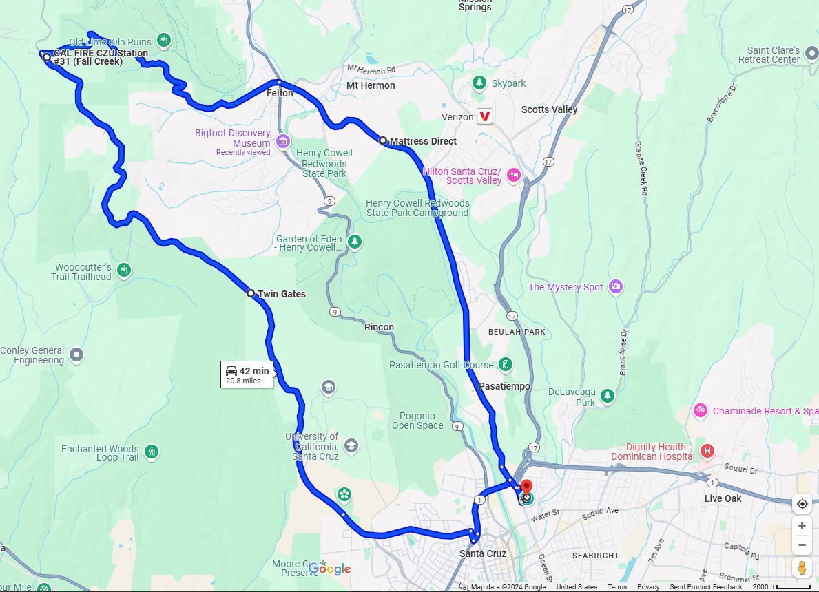
Refer to the map below, UCSC is at the south end of the loop. Coming from Highway 1 North, exit at Highland Ave, then left onto High St. you will see some historic ranch buildings. The road becomes Empire Grade. If it is not the holiday, suggest visiting the UCSC Arboretum and Botanic Garden. Too bad, it is closed when we visited.
Link to Google Map

Continued is the UCSC campus. There are several collages scatter around. This is not like any university I visited before. It is an university in a hugh forest! There are many trails for hikers and bikers as well. Right turn on Felton, we entered the redwoods area. All the trees are 4~6 stories high. After the winding road, we arrived at Felton. A town on Highway 9. If you continue north, that will lead you to the Big Basin Redwoods State Park. We took Graham Hill Road, passed the Roaring Camp Train Depot, a place kids woild enjoy where you can ride the train through the forest. (Holiday closed)

Continue on Graham Hill Road, we are back to Highway 1 at Santa Cruz. The loop total 21 miles. There are horses, dunkys, all sorts of things along the roads. On top of that, there are small cabins, pretty and cozy scatter around the forest. what a nice ride!


Friday, December 13, 2024

City Parks - Cupertino


Wilson Park

We have talked about county parks, state parks and beaches, let's brief a bit on the city parks. Give Cupertino as an example, not because she is the sister city of the Hsinchu, Taiwan, but the city I live.

There are total of 15 city parks. Introduction and nice pictures can be found on the city website. I would just share a few of mine. Usually a city park is small, some with a little league baseball field, some with a soccor field; a playground and picnic area. That's it.

Portal Park is on the Portal Ave. right behind my backyard. We are on the corner, som the other side is an elementary school. It was called Portal, but later changed to L.P. Collins Elementary School.
Portal Park

My house
In the morning, several seniors practice Tai-Chi here. The redwood can grow very big. You don't need to go far into the forest to see. Luckily they are taken care of by the city. 
Redwood cut off
Wilson Park could be the next closest. I used to jog from the N. Blaney, cross Stevens Creek Blvd south onto city trail, pass Wilson Park, then Creekside Park. Round trip is a bit short of 3 miles. Except the traffic light on the Stevens Creek Blvd, it is a nice route. The city trail can also lead to the library on the other end.

In summary, Cupertino is a nice city. Apple must have paid a lot of tax. However the housing is too expensive in the recent years. The only shopping mall Velco was demonished a few years ago, but not able to be rebuilt ever since.


Saturday, December 7, 2024

Stanford Dish Area


Other than city parks, county parks, state parks and beaches, here is another kind of place you can hike. The Dish is a special area to both Stanford and the surrounding communities, and it serves many purposes. (link to Stanford website)

We park on the Stanford Ave off Junipero Serra Blvd. Limited parking space, so you would want to come early. So wait a bit, there would be people leaving. Cross the Junipero Serra Blvd is the gated trailhead. The area map provides a good view of the area. We are at L1 now, follow the blue, you can choose clockwise or count clockwise. Total length is about 6KM. There is no shed thoughout the trail. Can't imagine it would be like in the summer.
To begin with is the uphill. Saw people running (slowly).

Once you come up to the hill, you can see the Stanford campus from a distance.
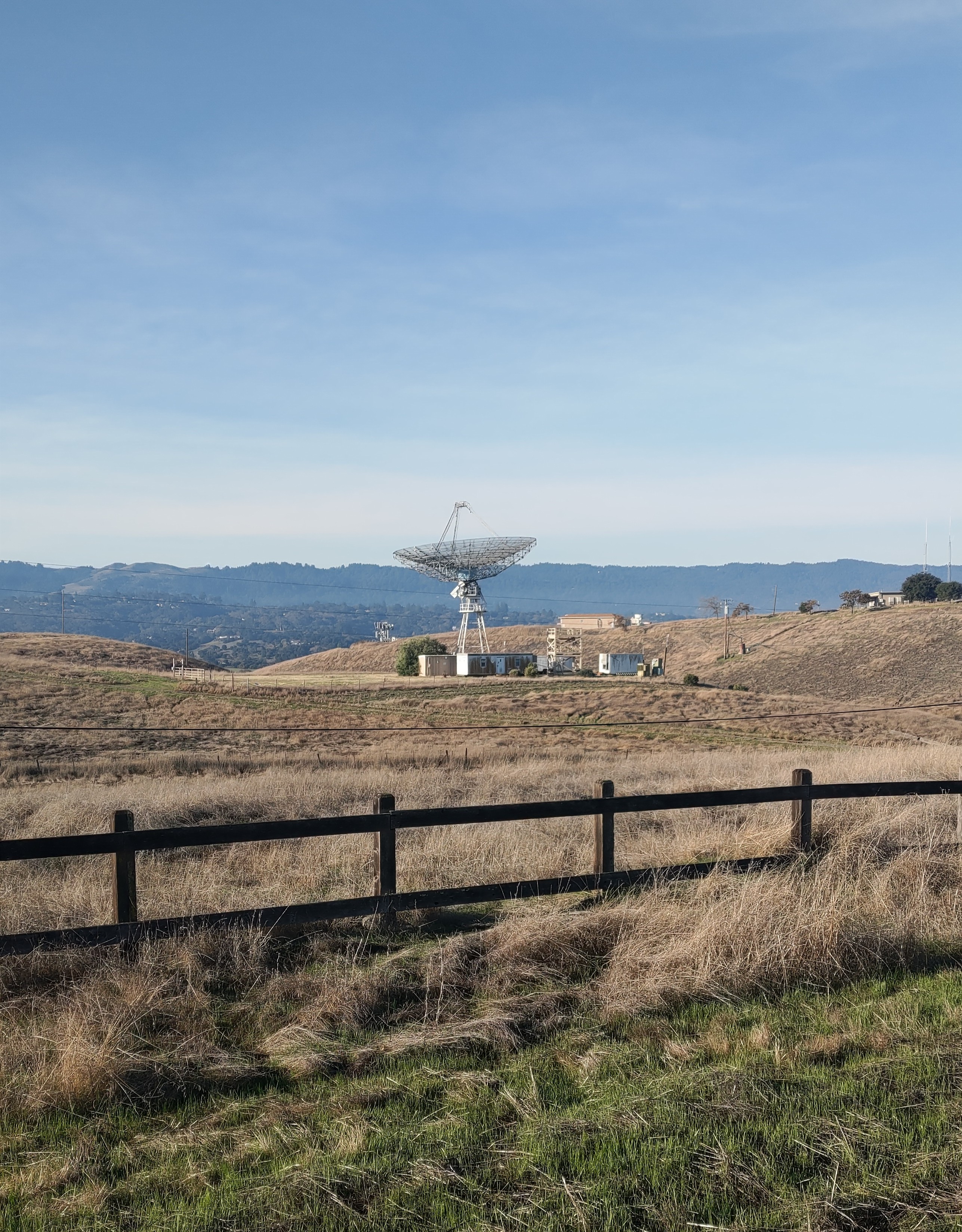
Turn to the other side, the 1st dish shows up. And not too far away, the 2nd dish (top of the page).
If you take the yellow path (ref to the map), you can reach the Pumpkin Patch at Webb Ranch.
Continued on, you cae see the Stanford Golf Course.
Mark on the pavement show you how far you have hiked.
Overall, it is a nice trail. With many up and down hills, provide you with enough exercise while enjoying scenic view.

Saturday, November 30, 2024

State Beaches close to Santa Cruz


Natural Bridge State Beach

There are many state beaches around the Santa Cruz area. Not too far from the Wilder Ranch State Park we just visited, it is Natural Bridge State Beach. This is certainly not that kind of beaches found in a tropical island. The terrain could be rough (below).
Not a typical beach

I'm not sure where the name came from. So I asked Gemini: Natural Bridges State Beach is named for the three naturally occurring arches that were once part of a large cliff that jutted out into the sea. These arches formed over millions of years through erosion by the Pacific Ocean. While two of the original arches have collapsed, the remaining arch is a popular attraction and gives the beach its distinctive name.
Arch on the left rock
For good picures, visit .gov website
The admission is $10 (parking fee). But you can park outside before you enter the gate. it is 20min free. if you don't plan to stay long.
Another attraction nearby is the Natural Bridge Monarch Trail. The best time to visit the trail to see the monarch butterflies is late October through November. This is when the butterflies are most abundant and active in the eucalyptus grove. Keep in mind the time could vary.

The trail consists of a zig-zag boardwalk (below) and trail to the pond and other wooded area. It is short.

See if you can spot the butterfly?

Two deers in the pond
The other side of the visitor center is the trail to the beach.
The arch from another direction
Since the trail is very short, we dicided to take a walk along the West Cliff Drive. Many visitors do the same. Some joggers, some walk their dogs. Enjoy the great view on one side, and nice houses on the other side.


Another state beach we visited is the Seabridge State Beach.
Walton Lighthouse - Seabridge State Beach
It is right south of the Boardwalk. We parked on the 1st Ave. walked toward the harbor, then lighthouse, beach and climb the stairs back to our car.

Seeing a boat in a distance. This is the east side of the Pacific Ocean!

This is another trip we made, planned to picnic at Capitola State Beach. Turn out it is too popular. No parking space. So we go further south and found the New Brighton State Beach in about a mile away.

New Brighton State Beach
A hugh parking lot with only a few cars. We came in early Dec. Probably this is built for the summer time. Before we left, saw this in the parking lot, saying the place was called China Beach or China Cove in the 19th century before they were forced out.
China Beach
There is a camp ground on site. I recalled we booked the camp site online, and did overnight camping in the summer break when kids were small.

Overall, it would be nice to stay in Santa Cruz for a few days. Although it is less than an hour drive getting from the South Bay. Highway Route 17 could jam up during the holidays. To avoid the traffic, go early and back early. Have fun!

Friday, November 29, 2024

Wilder Ranch State Park

Stylized by Google Photos

Wilder Ranch State Park is a California State Park on the Pacific Ocean coast north of Santa Cruz, California. The park was formerly a dairy ranch. Although many of the ranch buildings have been restored for use as a museum, they still keep the ranch name. Link to .gov website to see more photos and description.

My Original Photo

With its 7000 acres land and fantastic view of the Pacific Ocean, it is a must visit park in Santa Cruz. when kids were yound, we used to go to the Boardwalk when we visit Santa Cruz. Now we discover Santa Cruz has much more to offer than the amusement park and rides.

The admission is $10 per car. I should say the parking is $10 instead because if you come by bicycles, they will not charge you. Some people park outside along the Highway 1. That could be another option.
The map on the parking lot provides some guideance. We took the Old Cove Landing Trail. It is a loop, around 3 miles with half on the ocean front, some right on the edge of the cliffs.


There is trail lead to the beach front.

Short video of the view.


Saturday, November 23, 2024

Rancho San Antonio County Park & Open Space


Located on the west of Cupertino, about 5 miles from the city center, Rancho San Antonio County Park & Open Space is indeed a neighborhood park no one would get tired of. It is 4,277 acres or 1731 公頃(hectare)or 67大安森林公園. This may not be a good comparison. Take Vasona Lake County Park for example, it is 843 acres. So I would say around 1000 acres is the norm for a county park, Rancho is above the norm. (If you asked Google Gemini, the answer is she could not find a good answer!)

The nice thing about Rancho is there are so many trails. Short ones and long ones. All depend on what you need. Today we took the short one about 4km, ~10k steps. From the parking lot, to Deer Hollow Farm, take Coyote trail, then Equestrian parking back to the parking lot.

The trail is nicely maintained. Some in the wooded areas, some in open space. You bump into people very often, but you can always find some moments alone.
There are good view points, esp. the PG&E trail. It is called PG&E trail becuase there are electricity towers along the trail and the utility company maintain their facility and the trails.
Parking lot view
South Bay View

Recently they changed the name to Stephen E. Abbors trail. But you still see the old name here and there.
On another day, we tried the High Meadow Trail. As the name suggested, there are uphills. But not too bad. On the top, there is a good view of the South Bay.
There is a bench where you can have snack while enjoying the view. High Meadow Trail is longer. We spent about 2 hours, one hour to the scenic point, and 45 min down.

Compared with Taiwan's hiking trails, it is much natural. Taiwan's trails are just too many steps (wood, rock, bricks, you name it). Although I do appreciate those voluteers hand crafted some of the pavement and try to keep the nature the way it is. One nice thing about Taiwan's trails is you can always find good treats (food and drink) around the entrances!

The Wildcat Canyon Loop
The Wildcat loop is about 8km (above). 

基隆半日遊

  遠眺基隆嶼 今天來基隆 八斗子半日遊。基隆是臺灣僅剩的三個省轄市(另兩個是新竹跟嘉義)。基隆面積約是臺北的一半。感覺很大因為山很多。基隆約九成土地是丘陵、山坡地,市區依山谷和港灣發展,所以雖然面積不大,但道路彎曲、上下坡多,讓人感覺範圍比實際大。 「八斗子」的由來有好幾種說法...